Tocht Stappen Le Truel - costecalde - Photo
 Pascal Lemaire
Pascal Lemaire

Gebruiker

© OpenStreetMap contributors
Lengte
Lengte
8,7 km
Max. hoogte
Max. hoogte
755 m
Positief hoogteverschil
300 m
Km-Effort
Km-Effort  
12,7 km
Min. hoogte
Min. hoogte
511 m
Negatief hoogteverschil
300 m
Boucle
Boucle
Ja
Datum van aanmaak :
2023-03-12 12:48:22.974
Laatste wijziging :
2023-03-12 15:46:17.144

(0 Bericht)

Stappen
Stappen
2h54
Moeilijkheid : Medium

Scan deze QR-code om de tocht te openen in de SityTrail-applicatie

Gratisgps-wandelapplicatie

Logo SityTrail SityTrail

IGN / Geografische instituten

SityTrail uit de App Store downloaden SityTrail uit Google Play downloaden

Logo SityTrail SityTrail World

De wereld gaat voor u open

SityTrail uit de App Store downloaden SityTrail uit Google Play downloaden SityTrail op Huawei AppGallery downloaden

Over ons

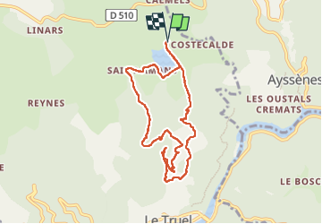
Tocht Stappen van 8,7 km beschikbaar op Occitanië, Aveyron, Le Truel. Deze tocht wordt voorgesteld door Pascal Lemaire.

Beschrijving

rando autour du lac de saint amans

Hoogteprofiel

Plaatsbepaling

Land:
France
Regio :
Occitanië
Departement/Provincie :
Aveyron
Gemeente :
Le Truel
Locatie:
Unknown
Vertrek:(UTM)
480388 ; 4880096 (31T) N.

Wandeltochten in de omgeving

Tocht Stappen Villefranche-de-Panat - Villefranche de Panat - Photo
Stappen
christiane01

Stappen

Gemakkelijk
(2)
Villefranche-de-Panat, Occitanië, Aveyron, France
10,4 km | 11,9 km-effort
2h 42min
Ja
Tocht Stappen  - J11: Ayssènes-Brousse le Château-190522 - Photo
Stappen
canardDenis

Stappen

Medium
, Occitanië, Aveyron, France
23 km | 33 km-effort
7h 29min
Neen
Tocht Stappen Villefranche-de-Panat - Villefranche de Panat à Salles Curan  - Photo
Stappen
yvesmonteillet

Stappen

Zeer moeilijk
Villefranche-de-Panat, Occitanië, Aveyron, France
24 km | 31 km-effort
4h 53min
Neen
Tocht Stappen  - Le chemin des Raspes - Ayssènes  - Photo
Stappen
tracegps

Stappen

Moeilijk
, Occitanië, Aveyron, France
14,1 km | 23 km-effort
4h 30min
Ja
Tocht Stappen Villefranche-de-Panat - randonnée Villefranche de panat  - Photo
Stappen
Pascal Lemaire

Stappen

Moeilijk
Villefranche-de-Panat, Occitanië, Aveyron, France
10,2 km | 12,7 km-effort
3h 10min
Ja
Tocht Stappen Le Truel - de truel au viala du tarn in live - Photo
Stappen
CASSISFRAMBOISE

Stappen

Moeilijk
Le Truel, Occitanië, Aveyron, France
21 km | 32 km-effort
5h 7min
Neen
Tocht Stappen Saint-Victor-et-Melvieu - rando du bosq le truel - Photo
Stappen
Pascal Lemaire

Stappen

Medium
Saint-Victor-et-Melvieu, Occitanië, Aveyron, France
8,3 km | 12,2 km-effort
2h 41min
Ja
Tocht Stappen Villefranche-de-Panat - lac de Villefranche de panat  - Photo
Stappen
yvesmonteillet

Stappen

Medium
Villefranche-de-Panat, Occitanië, Aveyron, France
10,3 km | 11,8 km-effort
1h 46min
Ja
Tocht Stappen Villefranche-de-Panat - Bosc Marty  - Photo
Stappen
yvesmonteillet

Stappen

Gemakkelijk
Villefranche-de-Panat, Occitanië, Aveyron, France
4,6 km | 5,6 km-effort
1h 15min
Ja


Sluiten
Mijn abonnementen